

Observations#
Important
Data Preview 2 has not yet been released. This website is currently under development.
The sky coverage (fields), filters, and number of visits (cadence).
Sky coverage#
Figure 1, below, gives an impression of the sky coverage of DP2. Caveat: a tract is shown on this map if it exists in the Butler sky map for DP2, and a tract outline being drawn does not mean that it will have a deep coadd image in every patch.
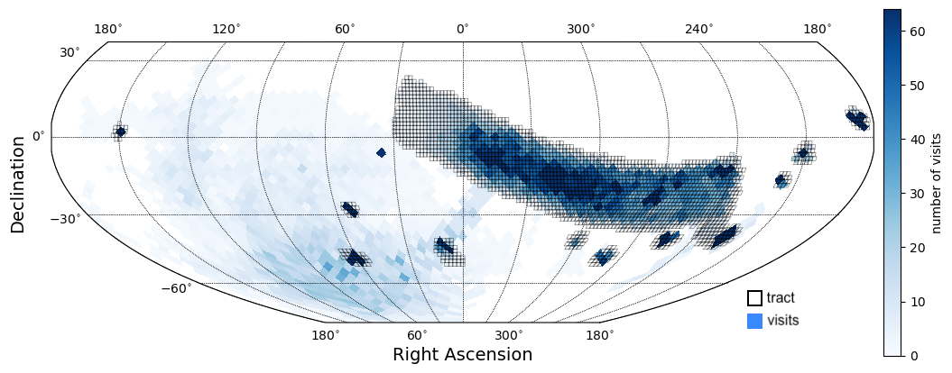
Figure 1: A preliminary map of the DP2 regions. Open black squares mark the locations of tracts in the skymaps (regions pre-identified for the creation of deep coadded images). Blue quadrilaterals are 19-sided HEALPix, similar in size to the LSSTCam 9.6 square degree field of view, of a density map of the number of visits. This plot is generated by one of the Tutorials.#
Wide-fast-deep region#
To be replaced with info about WFD. Describe lowdust, bulgy, and dusty_plane.
Small fields#
To be replaced with info about the small field survey areas. Include their names and central coordinates in a table.
Field name |
RA, Dec |
RA, Dec (deg) |
|---|---|---|
M49 (Virgo) |
12h29m36s +08d00m00s |
187.4, +8 |
Add new here |
x |
x |
Deep drilling fields#
To be replaced with info about the DDFs. Include their names and central coordinates in a table.
Field name |
RA, Dec |
RA, Dec (deg) |
|---|---|---|
COSMOS |
12h30m33s +02d13m48s |
150.11, 2.23 |
Add new here |
x |
x |
Filters#
Sky region |
u |
g |
r |
i |
z |
y |
Total |
|---|---|---|---|---|---|---|---|
WFD |
x |
x |
x |
x |
x |
x |
x |
M49 |
x |
x |
x |
x |
x |
x |
x |
COSMOS |
x |
x |
x |
x |
x |
x |
x |
Add new here |
x |
x |
x |
x |
x |
x |
x |
Epochs (nights)#
Sky region |
Epochs (nights) |
Visits/epoch |
|---|---|---|
WFD |
x |
x |
M49 |
x |
x |
COSMOS |
x |
x |
Add new here |
x |
x |
Coadd tracts#
Field name |
Tract IDs |
|---|---|
M49 |
x, x |
COSMOS |
x |
Add new here |
x |